| 19 May 2007 04:17 SOMALIA WATCH |
| Country | |
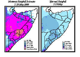
HEAVY RAINS INUNDATE SOMALIA Following the good to heavy rains which fell over most of Somalia during the last dekad of April 2000, more heavy rains continued to fall during the first dekad of May. Meteosat satellite imagery shows heavy to very heavy rains throughout most of Somalia, with the exception of the northern regions of Bari, Sanag and parts of Nugal. Very heavy rains are seen to have fallen over most of Hiran, Bakol and parts of Bay region during the dekad. The normal rainfall map confirms the heavy and well above normal rains in most parts of Somalia, which are typically light to moderate at this time of the gu season.
FSAU field reports from southern and central Somalia confirmed exceptional rains throughout Bay, Bakol, Middle Shabelle and Gedo, with the exception of the Belet Hawa, Luuq and Burdhubo areas. Rainfall in Middle and Lower Juba and in Lower Shabelle were described as localized. Reports from the north confirmed heavy rains in W/Galbeed, as well as in Sool, Sanag, Nugal and Bari regions, despite satellite imagery to the contrary for some areas in the northeast. Heavy rains throughout the Ogaden region in Ethiopia are providing relief to drought stricken pastoralists, but rains in the southeastern highlands of Ethiopia continue to feed the Shabelle and Juba rivers in Somalia. By the end of the first dekad of May, reports from Bardera indicated that the Juba River was almost full. The full crest of the Shabelle River was completed on 9 May in Lower Shabelle. Field reports from Hiran at the end of the dekad indicated that the water level in the Shabelle River was alarming, and that flooding was imminent. The climate outlook for most of Somalia was for below normal rains during the 2000 gu season, as a result of La Ni±a conditions (cold water in the eastern Pacific), as rains coming in over the Indian Ocean may be diverted south (causing possible heavy rains and flooding in southern Africa). However, according to climate experts, the La Ni±a episode has been accompanied by a number of very unusual meteorological events, which could explain the unusually heavy rains. Weather patterns in parts of the Horn have been influenced by moist air moving in from the Atlantic Ocean over the Congo Basin, causing unusual rains in Uganda, western Kenya and the Ethiopian highlands. At the same time, an unusual cloud pattern is covering the equatorial region from the mid-Pacific Ocean, west all the way to Africa, which could also be contributing to high rainfall in the Horn of Africa. In view of these meteorological events, climate experts agree that rains over the Horn have become unpredictable. NDVI satellite imagery show current vegetation levels well below normal for this time of year, reflecting the late start of the gu rains. As a result of the recent rains, good pasture and vegetation is likely throughout most of Somalia in the weeks ahead. [Country] |
|